Scalable Spatial Algorithm
Drainage Network Analysis
Lyu, F., Xu, Z., Ma, X., Wang, S., Li, Z., Wang, S. (2021). A vector‑based method for drainage network analysis based on LiDAR data. Computers and Geosciences, 2021, 104892, ISSN 0098‑3004. DOI:10.1016/j.cageo.2021.104892
Drainage network analysis is fundamental to understanding the characteristics of surface hydrology. Based on elevation data, drainage network analysis is often used to extract key hydrological features like drainage networks and streamlines. Limited by raster-based data models, conventional drainage network algorithms typically allow water to flow in 4 or 8 directions (surrounding grids) from a raster grid. To resolve this limitation, we describe a new vector-based method for drainage network analysis that allows water to flow in any direction around each location. The method is enabled by rapid advances in Light Detection and Ranging (LiDAR) remote sensing and high-performance computing. The drainage network analysis is conducted using a high-density point cloud instead of Digital Elevation Models (DEMs) at coarse resolutions
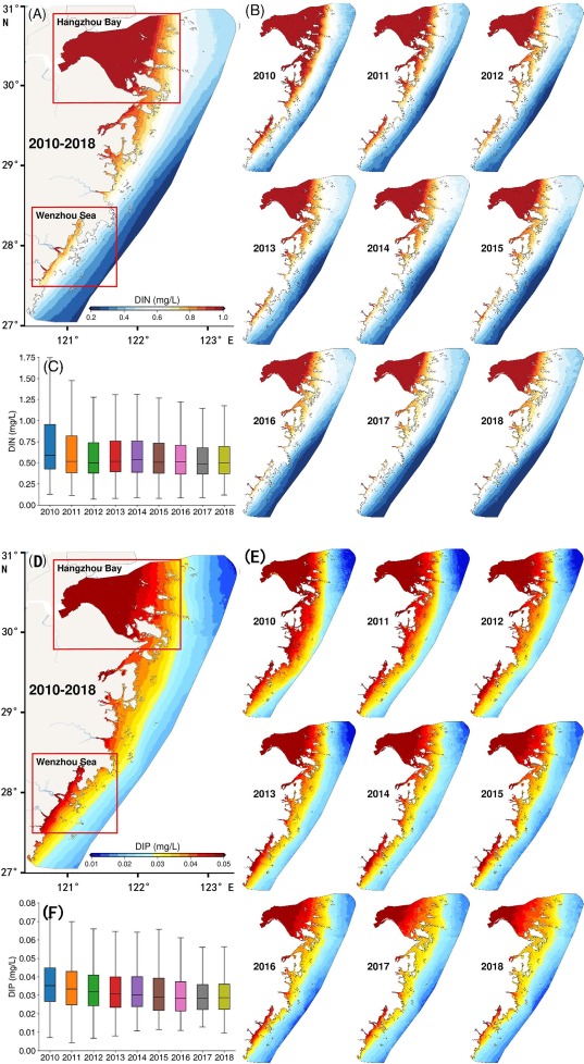
Spatiotemporal assessments of nutrients and water quality with Remote Sensing
Wu, S., Qi, J., Yan, Z., Lyu, F., Lin, T., Wang, Y., Du, Z. (2022). Spatiotemporal assessments of nutrients and water quality in coastal areas using remote sensing and a spatiotemporal deep learning model. International Journal of Applied Earth Observation and Geoinformation. Volume 112, 2022, 102897, ISSN 1569‑8432, DOI: 10.1016/j.jag.2022.102897
Revealing the spatiotemporal variations of nutrients in coastal waters is crucial to the understanding and evaluation of coastal environment, thereby providing efficient guidance for the aquatic environmental treatment. This study proposed a spatiotemporal-incorporated deep learning model, which is easily applicable to establish the quantitative relationships between measured environmental factors and large-scale satellite maps, and can reduce estimation errors by more than 40% compared with non-spatiotemporal-incorporated deep learning model. The spatiotemporal distributions of dissolved inorganic nitrogen (DIN) and dissolved inorganic phosphate (DIP) over 44400 km2 of the East China Sea on 8-day scale from 2010 to 2018 were obtained. Based on the spatiotemporal variations, the water quality patterns were depicted, and the fluctuation variations of the two essential nutrients were found in the harbors with complex anthropogenic influences, in the typical estuaries with multiple river inputs, and in the open seas with important fisheries. Although the concentration of DIN and DIP decreased by 24% and 19% in 9 years, respectively, the water quality level in the inshore sea has not been significantly improved, especially in autumn and winter. Further, we quantitatively analyzed the main factors of deteriorated water and provided sc